Table of Contents
GPS tracking with geoCapture
Description
Within the device management there is the possibility to access the location data of your machines and devices that you have with the DATAflor Partners geocapture Manage.
- current position and routes from GSP transmitters show (suitable for vehicles and construction machines)
- last position from beacons show (suitable for small devices)
- Find construction sites near GPS transmitters and beacons
Basic settings
Um BUSINESS To enable access to your GPS transmitters and beacons from geoCapture, enter the program parameters Enter the API key the material moisture meter shows you the APIKey that you received from geoCapture.
user rights
During the User administration Use detailed user rights to control the availability of functions and the visibility of data for the logged in user. The following user rights are available for GPS tracking with geoCapture:
| Law | Administrator | Main user | User |
|---|---|---|---|
| Right group: devices | |||
| View / edit geoCapture data | X | X | |
| Show geoCapture route | |||
| feature | necessary user right |
|---|---|
| assign a GPS transmitter / beacon from geoCapture to a device | View / edit geoCapture data |
| show the map with the current position of the GPS transmitter / beacons | View / edit geoCapture data |
| Also show the route from GPS transmitters on the map, including the time period selection | Show geoCapture route |
Assign GPS transmitter / beacon
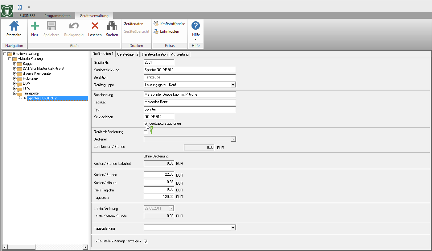
In the device management, mark the vehicle / device to which you want to assign a GPS transmitter / beacon from geoCapture and activate it  the option Map geoCapture.

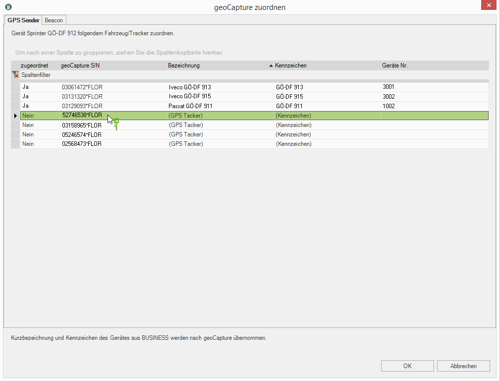
The dialogue Map geoCapture will be opened. On the tab GPS transmitter assign your vehicles the geoCapture GPS transmitter and on the tab Beacon To your small devices the geoCapture-Beacons. Mark the GPS transmitter / beacon that you want to assign to the device and confirm with [OK]. The GPS transmitters / beacons that are already assigned to a device are given a short description, identifier and device number. of the assigned device is displayed.

View GPS data
The GPS transmitter continuously transmit your standard location information directly to geoCapture via GPS coordinates. With the connection to geoCapture, in BUSINESS the current position of the vehicles can be displayed with a GPS transmitter.
The beacons do not send any GPS data themselves. For the localization of beacons a GPS receiver is required. This can be a stationary gateway (e.g. workshop, building yard) or a GPS receiver in a vehicle. If a GPS receiver locates a beacon, it sends the GPS coordinates as well as the date and time to geoCapture. This means that devices with beacons in BUSINESS the position at which the beacon was last electronically "seen" are displayed.
In the device management of DATAflor BUSINESS have you on the tab geocapture Access to the GPS data from geoCapture.
- If you select a device in the device tree, the geocapture displays the GPS data of this device.
- If you select a device group in the device tree, the tab geocapture the GPS data of all devices in this group are displayed.
On computers with Windows 10, the card is inserted directly into BUSINESS displayed.
On computers with Windows 8, Windows Server 2016 and 2019, the map can be opened via a link in the standard Internet browser. However, the map function is not available for Internet Explorer. Define a different browser as the default program in the settings of your Windows operating system.
Show position
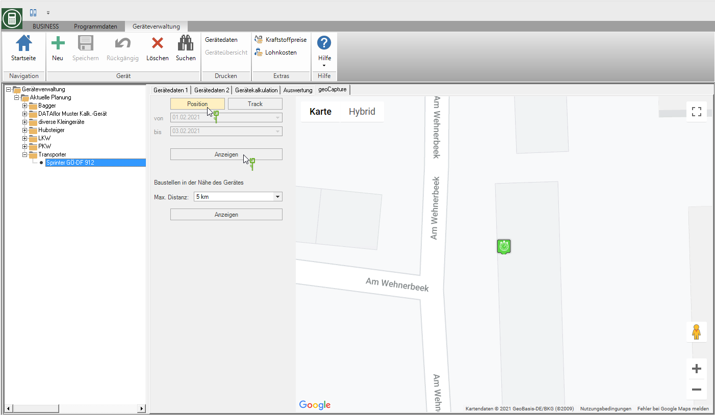
By opening the tab geocapture the map with the current / last position of the selected device or the devices of the selected device group is displayed by default. With vehicles that have a GPS transmitter are assigned by geoCapture, you have the choice to display the current position or the route of the transmitter within a period of time. To return to the current position display, select the function [Position] and confirm with [Show].

Show route
For devices that are assigned to a geoCapture GPS transmitter, you can also display the route of the vehicle or of all vehicles in a device group within a selected period.
- To do this, select the function Track, set the period and confirm with [Show].
- If you click on a point on the route, detailed information is displayed, e.g. what time the vehicle was at the selected location.
Find construction sites
With the proximity search you can find your construction sites within a defined radius. Put in the selection Max. Distance the search radius and confirm with Show. In the table below the map, all construction sites are listed Place of execution are in the vicinity.

With a double click on a construction site you can switch directly to the course in the project management.
Update transferred data
With the function geocapture in the menu BUSINESS you can update the data that has already been transferred to geoCapture, i.e. the in BUSINESS transferred changes made to geoCapture. This concerns the transferred device data as well as the LV and employee data for the Mobile time recording with geoCapture.
Select in the menu BUSINESS in the group Data transfer the function geocapture.


