Table of Contents
Georeferenced BILD draw up
Command: DFGEOTIFF
Description
With this function, images and drawing elements (e.g. shapes) from the CAD can be georeferenced BILD (TIFF format) can be generated and saved. The geodata in the BILD saved and not, as is well known, stored in an extra file.
Application
- Activate the command DFGEOTIFF.
- The dialog opens Georeferenced BILD draw up.
- Select the settings you want and confirm them with [OK].
- Now select the storage location where the TIFFRaster graphics should be filed.
The path where you saved the drawing is offered as the storage location.
- With [OK] exit the function and the georeferenced BILD is created.
Features
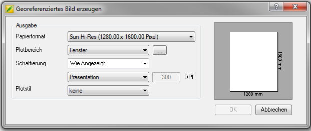
| Paper size | Displays the standard paper sizes available. Since a bitmap is created, the size of the plot is given in pixels. |
| Plot area | Determines the area of the drawing to be plotted. Advertising plots the view in the current one Viewport. boundaries plots the part of the current drawing area in which the objects are located. Window plots the part of the drawing you specify. If you select window, you can use the button [...] the plot area can be selected using two corners. |
| shading | Specifies how shaded and rendered windows are plotted, and sets the resolution level and DPI (dots per inch). |
| Plot style | Specifies the plot style table and provides a list of the currently available plot style tables. |