Table of Contents
Import shape
Command: DFSHPIN
Description
With this command you import external shape files into your drawing. You can edit these drawing objects and use them as a basis for planning, for example.
The file format SHAPE is a format for geospatial data developed by ESRI. It is a fairly simple format and not very demanding in terms of data quality.
The shape format consists of at least 3 files per shape file. The SHPFile is used to save the geometry data. The SHX-File serves as index of the geometry for linking with the attribute data of the DBF-File.
Only the elements of one object type can be saved in a shape file. It therefore contains either points, lines or areas.
Features
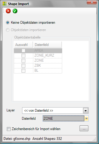
| Discard: Exits the Shape import dialog without importing the data. | |
| Take: Closes the Shape import dialog and imports the data into the drawing based on the settings. | |
| Do not import any object data | The geometric objects are imported into the drawing. The object data are not imported, but can be used to create the Layer can be used (see section Layer). |
| Import object data | The drawing objects and selected object data are imported into the drawing. This function is not yet available. |
| Object data table | In the object data table area, all columns from the associated database file (DBFFile). The selection of the data fields (columns) is not yet available. |
| Layer | Here you can either
|
| Data field | The data field contains a list of the data fields from the object data table. The objects are sorted into layers based on the selected data field. In this way, for example, the use of the objects can be recorded on the basis of the layer names. |
| Select drawing area for import | About the button [...] a rectangular area can be defined in the drawing to which the import is restricted. This is defined in the drawing with two mouse clicks. After the first click, drag the mouse pointer to highlight the desired area and then click a second time. The objects that are inside the rectangular window (with the corresponding coordinates) are imported. This option is particularly useful when working with a lot of object data. |