Table of Contents
Import gray image
Command: GEIMPORT
Description
With this command you import the current map section from Google Earth into your drawing. You can use this as a basis for planning or as an overview map, for example.
Application
- Start Google Earth and select the map section to be inserted.
- Switch to your drawing in DATAflor CAD and call the command Import gray image .
- The map section is inserted into the drawing and saved in DATAflor CAD displayed.
Functionality
The map section visible in Google Earth is displayed in DATAflor CAD inserted as a bitmap with grayscale. The Gauß-Krüger coordinate range is used and the image is automatically aligned to the north. It is possible that this will insert the image rotated.
All images are on the layer Google Earth images inserted.
Note
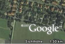
The Viewing height must not be more than 50 km. Zoom in accordingly. You can find the viewing height of your current view in Google Earth in the lower right corner.
For use in DATAflor CAD you need the View from above. If the view is inclined, set the top view before executing the command.
In Google Earth, you can use the Navigation controls Zoom in, tilt and rotate the image around the viewpoint at the top right.
Use the zoom slider to zoom in and out. Click the icons at the end of the slider to zoom in and out completely.
With the tilt slider change the slope of the terrain. Move the slider to the left to tilt to top view or to the right to tilt to horizontal view. Click on the icons at the end of the slider to fully reset the tilt to top view or horizontal view.
The inserted cards are stored in the user directory of DATAflor CAD in the folder Google Earth \ Images filed.
Will the image be in DATAflor CAD shown distorted, the cause lies in the activated terrain heights. To deactivate this, open the Options from Google Earth and uncheck the option in the Terrain quality area Show terrain.
Application in the layout
You can also insert images in the layout, but the functionality here differs from that in the model. After using the command Import gray image you will be asked to specify an insertion point. Then scale the image to the desired size and rotate it if necessary.
The Google Earth Pro product must be purchased for commercial use. Details can be found at: http://earth.google.de/products.html
(Source: Text is partly from the Google Earth user manual)