Table of Contents
Import image and terrain
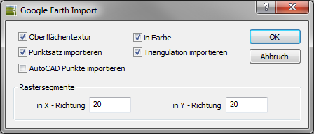
Command: IMPORT2
Description
This function is an extension of the function Import color image. In addition to importing the terrain model data, the Google Earth image can automatically be placed as a texture on the terrain model. With the help of a map section, terrain model data can be generated, which is then used in the visualization with the command RENDER should be used.
Features
| surface texture | Creates a surface texture based on the Google Earth image. |
| in color | Creates a colored surface texture. |
| Import point set | Create a DATAflor Point set based on the elevation of the terrain from Google Earth. The point set is visible. The settings can be made in Quick DGM be adjusted. The point set is on the layer 0_DTM_PointSet_Google Earth. |
| Import triangulation | Creates a triangulation based on the generated point set. If this option is activated, the point set is not visible afterwards. The settings can be made in Quick DGM be adjusted. The surface is on the layer 0_DGM_Triangulation_Google Earth created. The number of points determines the appearance of the surface. |
| Import AutoCAD points | Generated in place of the DATAflor Points individual AutoCAD points. These are on the current layer. |
| Grid segments | With these values you determine the point density of the DTM point set and the AutoCAD points. For this purpose, the map section is divided into segments according to the entered values. The preset value of 20 grid segments can be increased to a maximum of 1000 for the X and Y directions. If the grid is not straight, the cause is the difference in height between the points used (curvature of the earth). |
The Google Earth Pro product must be purchased for commercial use. Details can be found at: http://earth.google.com/intl/de/